Family Christmas trip to the desert. We flew into Las Vegas airport, then spent two nights at Tahiti Resort, a few miles from the Strip.
 |
Lobby of Tahiti Resort
|
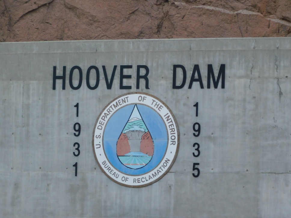
Hoover Dam
We had one full day in Las Vegas and visited Hoover Dam. The dam sits on the border between Nevada and Arizona. It protects against floods; stores water for irrigation and usage; and provides hydroelectric power. Interestingly, California is allocated the majority of the power generated by the dam - over 50%. Arizona and Nevada use around 20% of the power. Lake Mead is very low due to ongoing drought.
We did the tour which went inside the dam and included walks through the construction tunnels and a visit to the power plant. We got to see the generators and the large pipes where water flows. We also got several close views of the dam.
 |
| Diagram showing the layout of the dam structure. |
 |
| One of the pipe where water flows more than 100,000 cubic feet per second. |
 |
| Generators inside the dam |
 |
| One of the construction tunnels. |
 |
| Close up view of the dam, from inside the power plant. |
 |
| Walking on top of the dam, with the Memorial Bridge in the background. |
After touring the dam, we walked across the Mike O'Callaghan - Pat Tillman Memorial Bridge. The bridge opened in 2010, and its purpose is to allow through traffic to bypass the dam when crossing the Colorado River. The bridge includes a pedestrian walkway with panoramic views of Hoover Dam.
 |
| View of Hoover Dam from the Memorial bridge. |

Death Valley - Day 1
We drove 2 hours west, into Death Valley National Park. Although Death Valley has a reputation for being extremely hot (common for temperatures to exceed 120F in summer), winter is actually pleasant and temperatures perfect for long hikes. Typical winter temperatures in Death Valley are 40s at night and 65-75F in the day. Mountain areas are colder. Upon arriving the park, we visited Dante's View for an overlook of the basin with the mountains in the background.


We stayed at the Ranch in Death Valley - also known as the Oasis. The lodge is in a great spot for watching sunrises and sunsets. There are three restaurants within the Ranch - Saloon, Ice Cream Parlor, and 1849 Restaurant which is a buffet. I recommend the Saloon - great western atmosphere and good food although pricy. For a cheaper option, there is the Toll Road restaurant in Stovepipe Wells which is 30 minute drive from the Ranch. If money is no object, check out the dining room at the Inn which is one mile from the Ranch - great views and an elegant dining area.
 |
| Sunrise at the Ranch |
 |
| The sunrise creates red tint on the mountains. |
 |
| Sunrise creating an orange tint on the mountain snow. |
 |
| Saloon restaurant, which is a replica of the old west. |
 |
| Fireplace outside the Saloon. |
Death Valley - Day 2
Zabriskie Point, where there used to be a lake millions of years ago. Over time, tectonic activity caused the earth to shift which tiled the region and caused mountains to form.
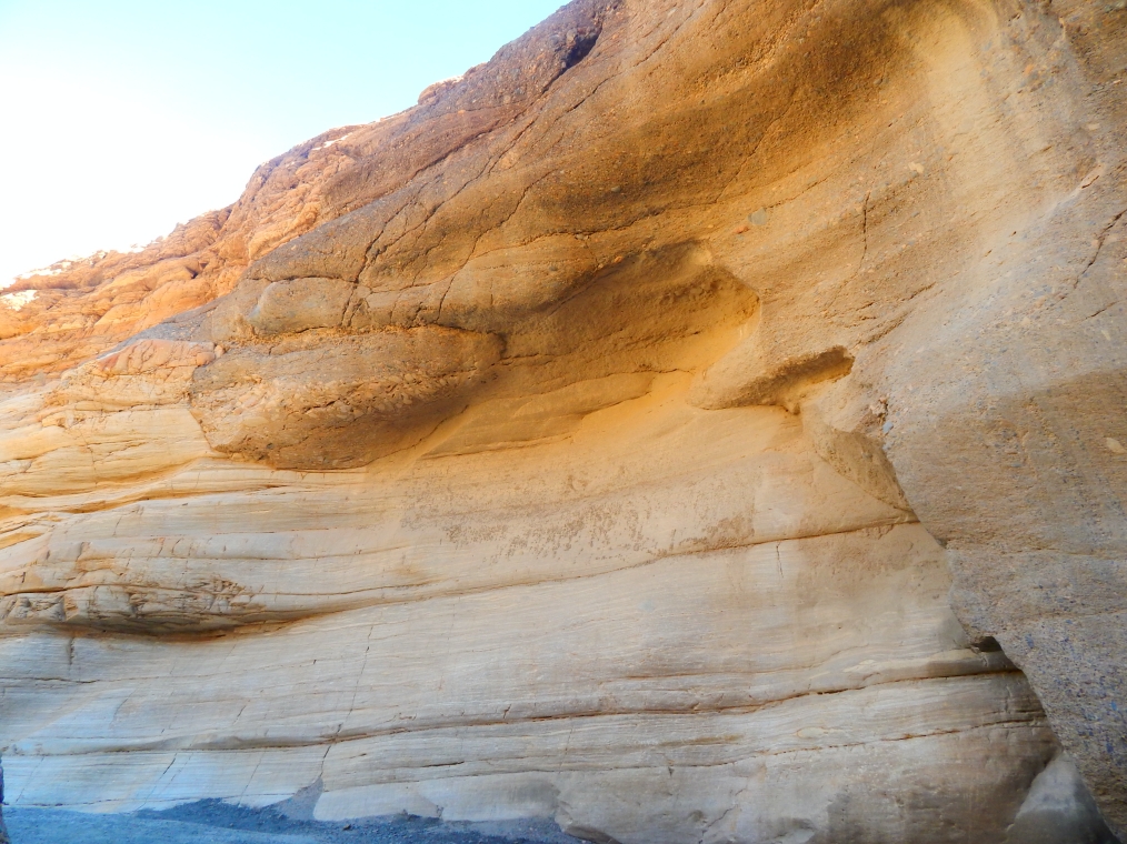
Hike in Mosaic Canyon. Running water from floods carved through the rock, creating the canyon. The hike goes through narrow corridors with marble walls. The trail reaches a point with several tall rocks - you can choose to be adventurous and climb the rocks to continue. During the hike, we heard several fighter jets flying nearby. Parts of Death Valley are used in military jet training - more in the Day 3 section.
Visited Mesquite Sand Dunes in the late afternoon. We attended a ranger hike over the dunes and also had a presentation about the dunes.
Summary of the presentation:
There are 3 factors which created the dunes.
1) Sand. Particles generated from erosion of rocks plus minerals formed the sand. See picture for a close up.
2) Lake Manly. The floor of Death Valley used to be a lake. Over time, the mountains surrounding the valley grew (due to tectonic activity) and eventually rose high enough to block most rain and trap heat. This combination of extreme heat and dry weather caused Lake Manly to evaporate leaving behind salt flats (more in Day 4) and exposing the canyons.
3) Wind. As the wind blew, it carried the sand into the canyons. Over time, the wind blew enough sand into the canyon that dunes started to form. The dunes grew larger as wind blew in more sand.
The largest of dunes are called Star Dunes, and they are located 1 mile from the parking lot. I hiked to the Star Dunes in a previous Death Valley trip and it is a real workout climbing to the top.
Throughout the sand dunes are mesquite trees. These trees have tiered roots that go 200+ feet deep and can tap into underground water to survive and grow.
Various animals live in the sand dunes. Including rats, sidewinder rattlesnakes (not likely to be found during winter), foxes, and coyotes.
 |
| Close up of the sand particles - 1000 micrometer which is equal to 1 millimeter or .00004 inch. |
 |
| Mesquite tree |
After the presentation, we stayed to watch the sunset at the sand dunes.
Death Valley - Day 3
We drove past Panamint Springs to the Father's Crowley Overlook. Here, we are at the rim of Rainbow Canyon which is where Star Wars was filmed and thus the canyon has nickname Star Wars Canyon. The canyon has shades of red, grey, and pink which are similar to Star Wars planet Tatooine. Rainbow Canyon is also where United States Air Force and Navy conduct flight training. Visitors can sometimes see fighter jets flying over the canyon. We heard a few fighter jets but they were flying too high to see clearly.
We then drove to Wildrose Canyon and visited the Charcoal Kilns. The kilns were built in 1877, and for a few years were used to convert tree wood into charcoal. This charcoal would then be transported to mines to use as fuel for mining operations. Each kiln has a few pieces of charcoal inside. The kiln is a great picnic location. The kilns are at a higher elevation, so temperatures are quite a bit cooler. The nearby mountains even had snow. That is correct - snow inside Death Valley!
Death Valley - Day 4
Devil's Golf Course, which is a large field of rocks and salt crystal formations. It got its name from a guidebook which commented "only the devil can play golf" due to its rough surface. The course is in a valley which used to be covered by Lake Manly. The lake contained minerals which were carried from the mountains by water runoff. Since Death Valley has no rivers leading to oceans, the minerals stay in the valley. As the lake water evaporated minerals were left behind and formed the salt compounds. Warning: if you venture out on the course, step carefully. The salt formations are sharp and may cut if you fall.


Attended a ranger presentation at Badwater Basin, which is a salt flat surrounded by mountains. It is the lowest elevation in North America, at 282 feet (86m) below sea level. The expansive white areas are salt. Like Devil's Golf Course, the basin was under Lake Manly. As the lake dried, the minerals were exposed and eventually mixed to form salt. The salt here is made of the same minerals as table salt - sodium and chloride. The ranger tasted the salt!
 |
| Floods happen in Badwater Basin on occasion. Most recent was this past August. Ponds, like the one in this picture, form as a result of the floods. |
 |
| Parts of the basin have groundwater and the water rises through the salt and evaporates - this creates the polygons. |
Artist Drive goes through hills carved by water flowing. Volcano eruptions deposit metals. Oxidation and chemical reaction of metals give the hills colors. Iron produces red, pink and yellow. Mica produces green. Manganese produces purple. There are two areas to stop in Artist Drive. The first stop is an overlook into the valleys.
 |
| Some mountains look like mint chocolate. |
 |
| Cloudy at Artist Drive, but we could see peaks of sunshine in the distance. |
The second stop is Artist Palette. The hills have many colors, producing a beautiful display. There are a few hiking trails to get close to the colorful hills. It was cloudy when we visited, which actually helped with taking pictures. Under direct sun, some of the colors may appear washed out and sunshine also produces shadows which can case parts of the hills to look dark.
Hike in Golden Canyon to Red Rock Cathedral.
 |
| Steak dinner at Toll Road restaurant in Stovepipe Wells. |
Our return flight was landing in Austin at sunset. Very beautiful colors in the sky. And as a nice bonus, we all got upgraded to first class!